9 Lab 9—Structural geology
WHAT IS STRUCTURAL GEOLOGY?
Structure geology refers to the subdiscipline within the geosciences that studies the physical responses of the Earth’s crust to mechanical forces. The forces that rocks are subject to are referred to as stresses. Depending upon how great the stress is and how rapidly the stress is applied to rocks, they may deform permanently, temporarily, or not at all. This deformation of rocks in response to stress is called strain.
Structural geologists measure the strains exhibited in rocks as geologic structures to understand the stress fields that caused those deformations. This can then help them determine the forces exerted during the tectonic history or other events in the region they are studying.
The structures in rocks that exhibit strain may fall into one of these categories: joints, shear fractures, faults, folds, cleavage, foliations, lineations, or shear zones. When rocks have a ductile response to stress, they fold without breaking. Then the response is brittle, the rocks break, resulting in faulting.
Types of folds
Anticline—linear axis, oldest rocks in the center of the fold, limbs generally dip away from the hinge
Syncline—linear axis, youngest rocks in the center of the fold, limbs generally dip toward the hinge
Dome—nonlinear, oldest rocks in the center, rocks dip away from the center in all directions
Basin—nonlinear, youngest rocks in the center, rocks dip toward the center in all directions
Figure 9.1 Parts of a fold, using an anticline for an example (Ohare, 2019)
Strike-slip—rocks are displaced along the strike of the strata. Strike-slip faults can be left lateral (sinistral) or right lateral (dextral). If you were to physically stand on one side of the fault and look at the other, that other side would be displaced to the right or left relative to the side you are standing on. The direction to which it is displaced determines its name. See Fig. 9.2 below for an illustration of strike-slip faults.
Figure 9.2 Strike-slip faults as seen from the top, looking down (plan or map view). Left-lateral strike- slip fault on the left, right-lateral strike-slip fault on the right.
Dip-slip—rocks are displaced along the dip of the strata. Dip-slip faults have a hanging wall above the fault-plane surface and a footwall below the fault -plane surface. In cases where the hanging wall has moved down-dip relative to the position of the footwall, this is called a normal fault. In a reverse (or thrust) fault, the hanging wall has been displaced upward relative to the footwall.
Hanging wallFootwall
Hanging wallFootwall
Figure 9.3 Dip-slip faults as seen from the side (cross-section view). Normal fault on the left and reverse fault on the right.
Oblique-slip—the displacement of the fault is a combination of strike-slip and dip-slip
HOW DO WE MEASURE GEOLOGIC STRUCTURES?
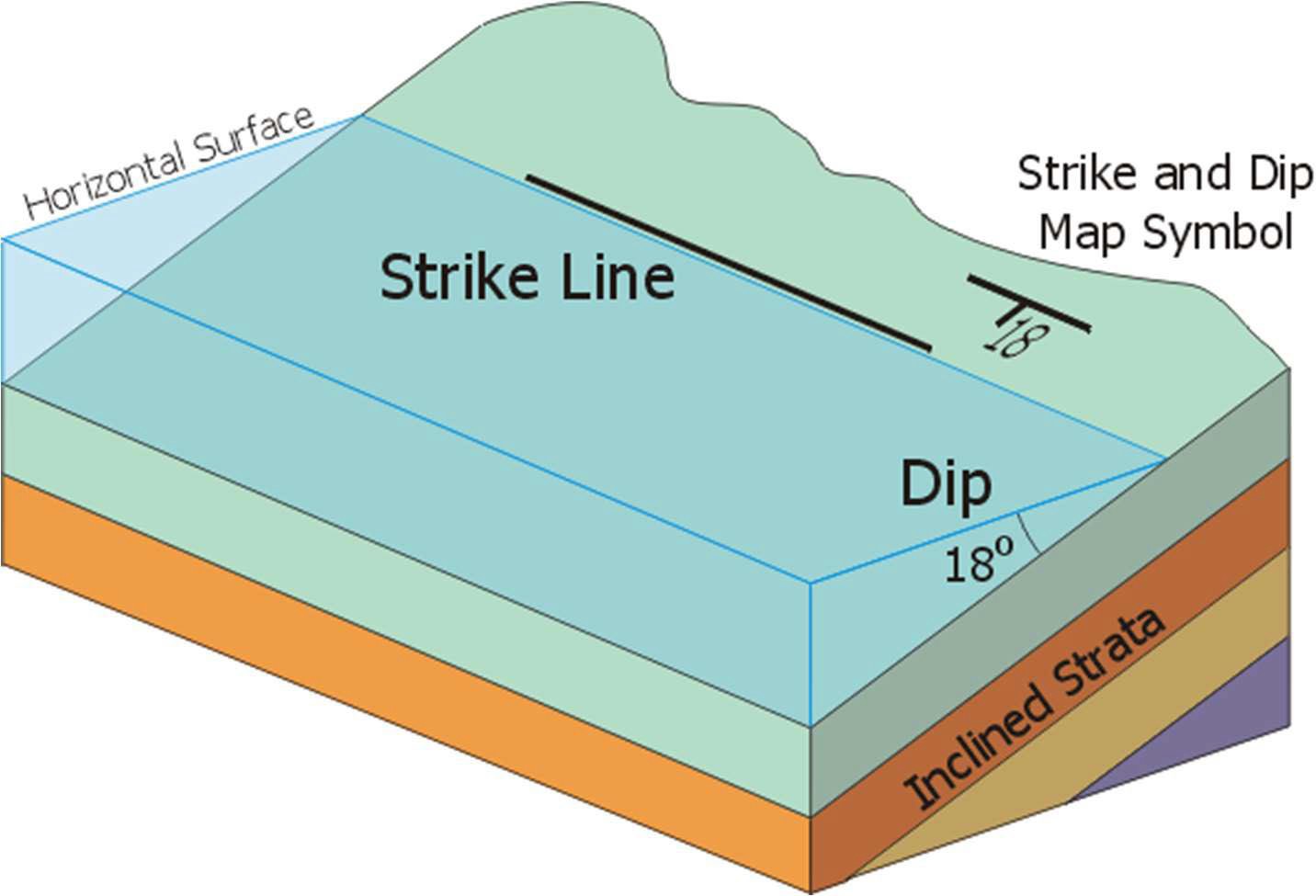 Two measurements are used in structural geology to indicate the positioning of rock units: strike and dip. To envision the way strike and dip are defined, you can intersect the geologic unit of interest with an imaginary horizontal plane. The azimuthal (compass-direction) orientation of the intersecting line is the strike direction. The dip direction is perpendicular to the strike direction, and the angle at which the bed slopes down from the horizontal is the dip angle. Figure 9.4 illustrates the relationship between strike and dip on geologic strata and shows how strike and dip are indicated on a map.
Figure 9.4. Strike
and dip illustrated (Geologyin crossection, 2019).
HOW ARE GEOLOGIC STRUCTURES INDICATED ON MAPS?
The following three tables by Dawes and Dawes (2011) summarize many structural symbols that are used on geologic maps.
|
Strike and Dip Symbols |
||
|
Strike and dip are a way of representing the three-dimensional orientation of a planar surface on a two-dimensional map. The strike is the compass direction of a horizontal line on the plane. All the horizontal lines on a plane are parallel, so they all have the same characteristic compass direction. The dip is the angle at which the plane slopes downhill from the horizontal, at its maximum slope, which is at right angles (90�) from strike. |
||
|
Map Symbol |
Definition |
Explanation of symbol |
|
|
strike and dip of beds other than horizontal or vertical |
strike (longer line) is horizontal line on bedding plane strikeparallelsnearbycontacts between stratified rocks dip shows which way beds run downhill dip angle, number at end of dip symbol, is how much beds tilt down from horizontal |
|
|
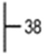
horizontal beds |
because the bed is horizontal it strikes in all directions because the bed is horizontal, the dip is 0% |
|
|
strike and dip of vertical beds |
strike (longer line) is horizontal line on bedding plane because the bed dips vertically (has a 90% dip), it dips equally in either direction at right angles to strike, so the dip line is shown extending in both directions |
|
Geologic Fault Symbols |
||||
|
Type of Fault |
Map Symbol |
Definition |
Type of Regional Stress |
Geologic Associations |
|
normal |
|
hanging wall down, footwall up |
tension |
zones of crustal extension divergent plate boundaries edges of horsts and grabens Basin and Range region |
|
detachment |
|
low-angle normal fault, footwall – gneiss, hanging wall – shallow- crust rocks |
tension |
boundaries of metamorphic core complexes |
|
thrust |
|
hanging wall up, footwall down |
compression |
zones of crustal compression convergent plate boundaries |
|
reverse |
|
high-angle (45° or more dip) thrust fault |
compression |
zones of crustal compression convergent plate boundaries |
|
strike-slip |
|
rocks on either side move horizontally in opposite directions |
shear |
continental margins undergoing oblique (not straight on) plate convergence transform plate boundaries |
|
oblique-slip |
|
combines horizontal and vertical motion |
combination
|
orogenic mountain belts continental margins undergoing oblique (not straight on) plate convergence |


|
Geologic Fold Symbols |
|||
|
Type of Fold |
Map Symbol |
Definition |
Appearance of Beds in Map View |
|
anticline |
|
up fold |
roughly parallel stripes dip away from center (away from axis) oldest at center (along axis) youngest farthest from center |
|
plunging anticline |
|
up fold with tilted axis |
roughly a U-shaped pattern plunges in the direction that the U points oldest at center (along axis) youngest farthest from center |
|
syncline |
|
down fold |
roughly parallel stripes dip toward center (toward axis) oldest farthest from center youngest at center (along axis) |
|
plunging |
|
down fold with tilted |
roughly a U-shaped pattern plunges in direction U opens oldest farthest from center youngest at center (along axis) |
|
syncline |
axis |
||
|
monocline |
|
strata tilted in one direction |
all dip in same direction |


|
structural dome |
|
upward bulge in layered rocks |
roughly a bull’s eye pattern dip away from center oldest in center youngest farthest from center |
|
structural basin |
|
downward bulge in layered rocks |
roughly a bull’s eye pattern dip toward center youngest in center oldest farthest from center |

In these lab activities, we focus on the responses of one material to a variety of stress. Then we examine various folds and faults in more detail.
PART 1: EXPLORING STRESS AND STRAIN
Stress magnitudeStress rate
Working with a piece of silly putty, subject it to various stresses—large or small force, force applied rapidly or gradually—and combinations of those stresses. How does it strain in response to each of these? Describe the behavior of this material in the table below. What structures could result from these conditions?
|
|
|
High stress |
Low stress |
|
Stress applied quickly |
|
|
|
|
Stress applied slowly |
|
|
|
You are provided with six flat diagrams that can be folded into 3-D blocks. It isn’t necessary to do the folding to complete the exercise, but you may find it helpful. To fold the blocks, remove the pages from your lab manual, cut them out, and fold to form a block. Each diagram has a series of geologic units that are drawn in on some but not all of the faces. Your job is to draw the contacts of the units on the remaining faces and complete any other instructions or questions associated with each block.
Remember that along the edges of the 3-D box – where the sides meet the top or where the sides meet each other – the geology must match. That is, the geology along a cross-section must match the geology of the map where the two planes intersect. You can use this to accurately transfer information from the map to the cross sections or vice versa.
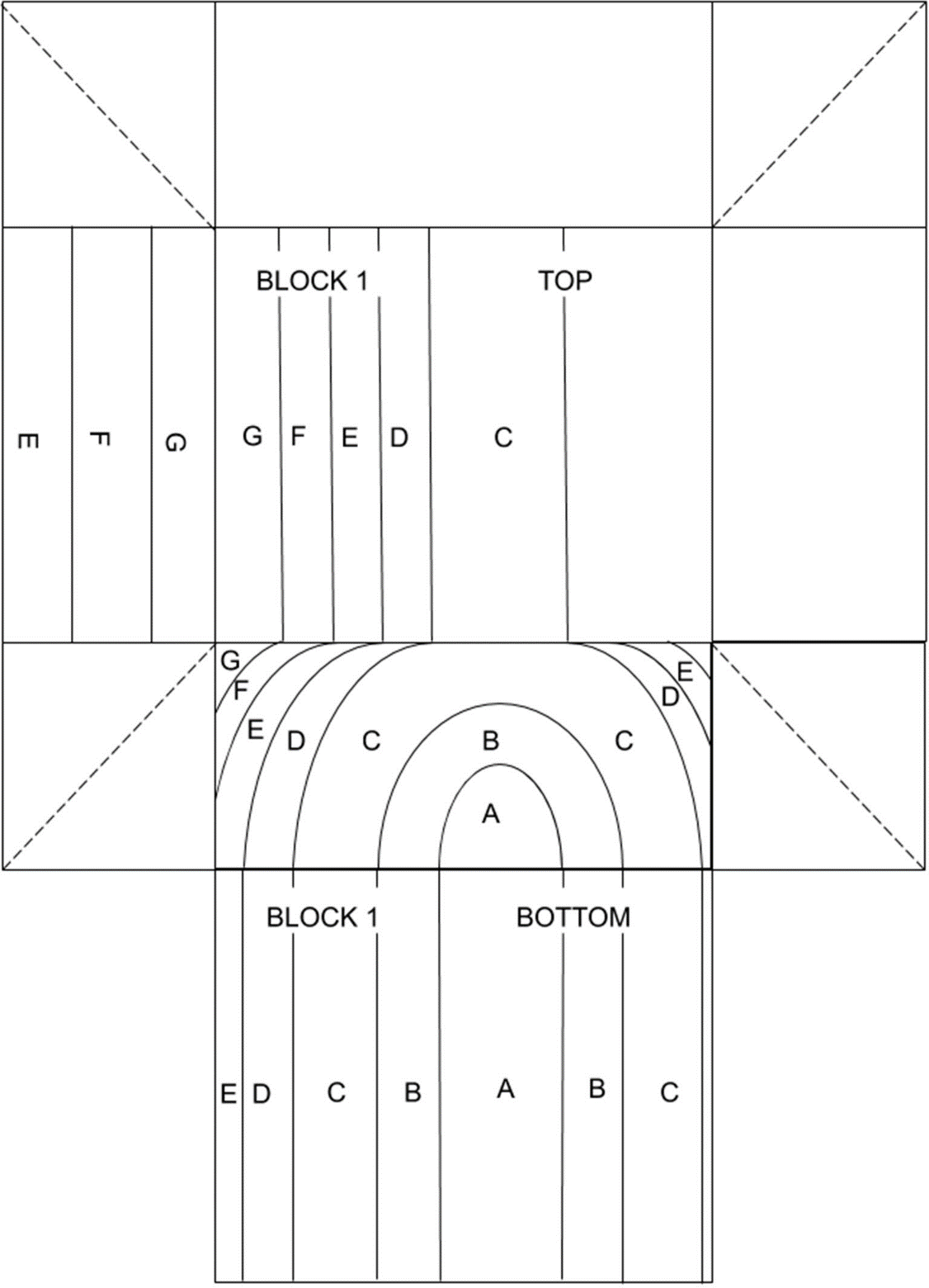
BLOCK 1
Complete the map portion of this block diagram. Draw in all necessary contacts and label each unit.
Name the structure that occurs in the diagram.
Draw the proper symbol for that structure on the map portion of the diagram.
On the map, add one representative strike and dip symbol for each limb of the fold.
Which unit is the youngest? Which is the oldest?
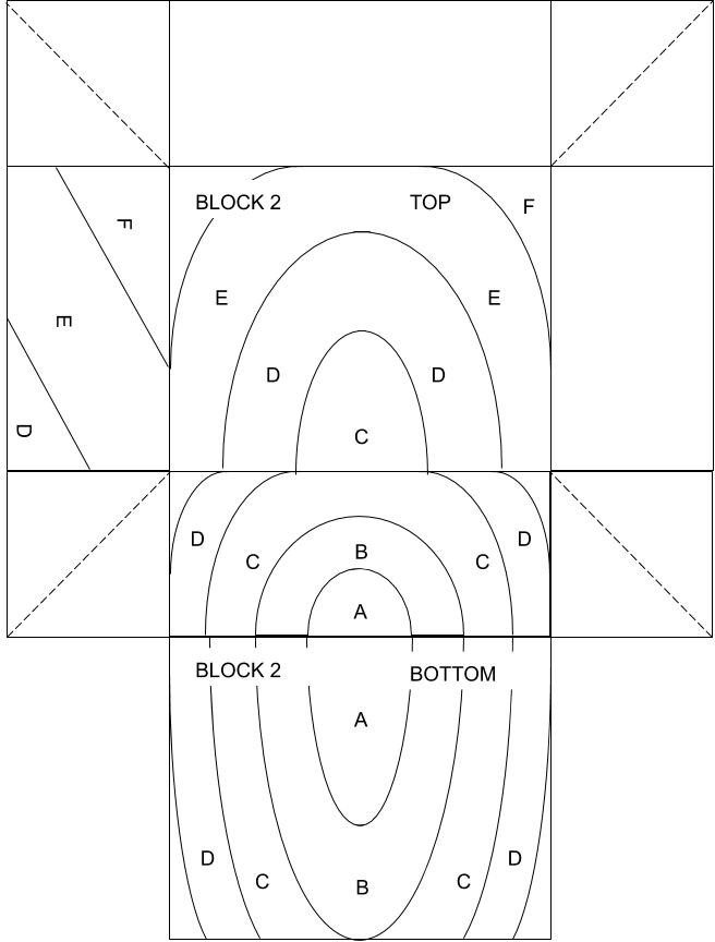
BLOCK 2
Complete the two remaining sides of this block diagram. (Some information has been provided for you.) Draw in all contacts and label all units.
Put accurate strike and dip symbols on each unit on the map.
What structure(s) occurs in this diagram?
Is/are the structure(s) plunging or not plunging?
Draw the appropriate symbol(s) for this/these structure(s).
Which unit is the youngest? Which is the oldest?
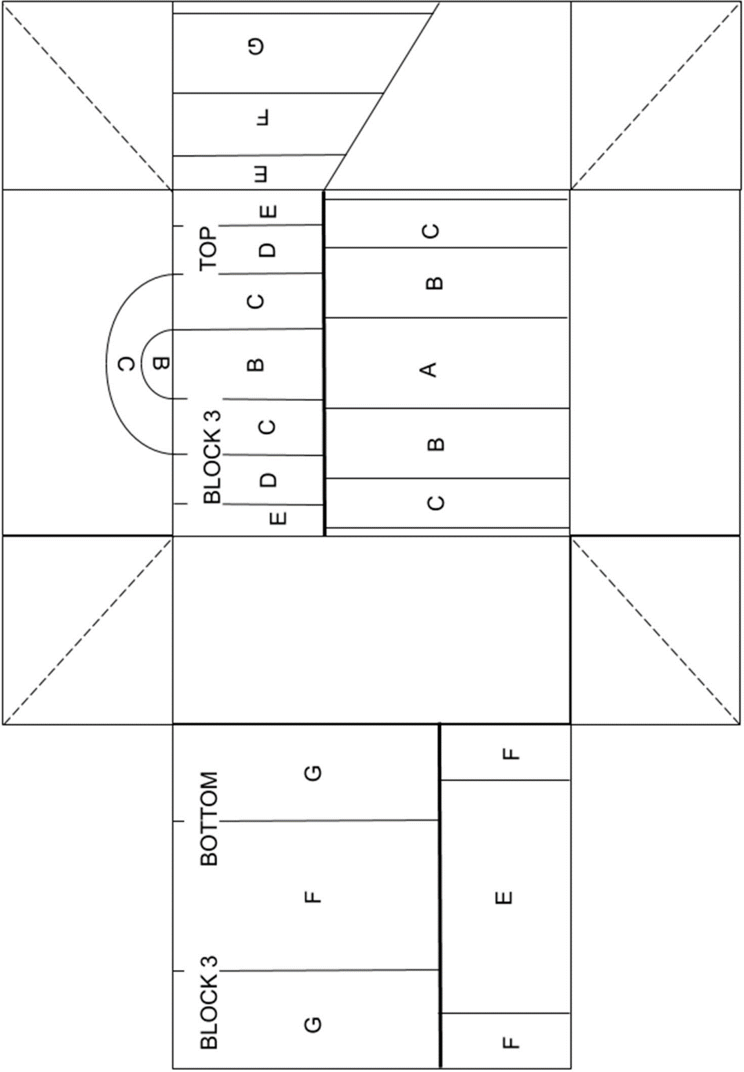
BLOCK 3
Complete all four cross-sections for this diagram. (One cross-section has been started for you.)
Put accurate strike and dip symbols on each unit on the map.
What structure(s) occurs in this diagram?
Is/are the structure(s) plunging or not plunging?
Draw the appropriate symbol(s) for this/these structure(s).
Add arrows to the map or cross-sections of the block diagram to indicate the nature of offset on the fault.
Which unit is the youngest? Which is the oldest
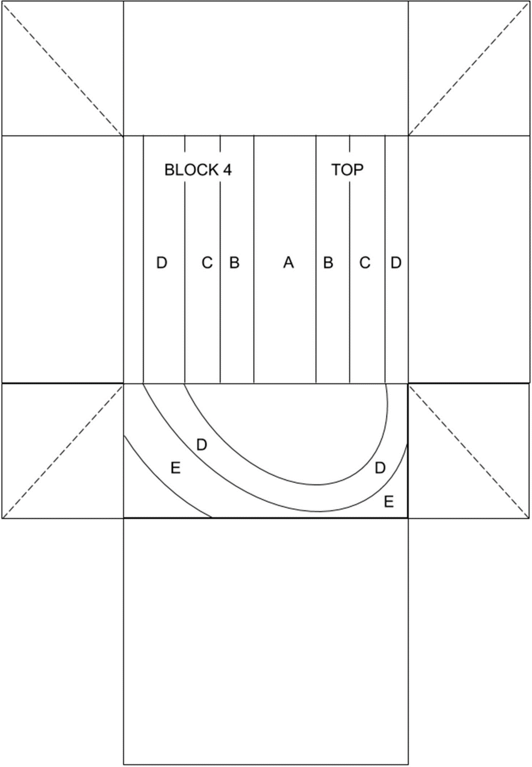
BLOCK 4
Complete the remaining sides of this block diagram. (Some information has been provided for you.) Draw in all contacts and label all units.
Put accurate strike and dip symbols on each unit on the map.
What structure(s) occurs in this diagram?
Is/are the structure(s) plunging or not plunging?
Draw the appropriate symbol(s) for this/these structure(s).
Which unit is the youngest? Which is the oldest?
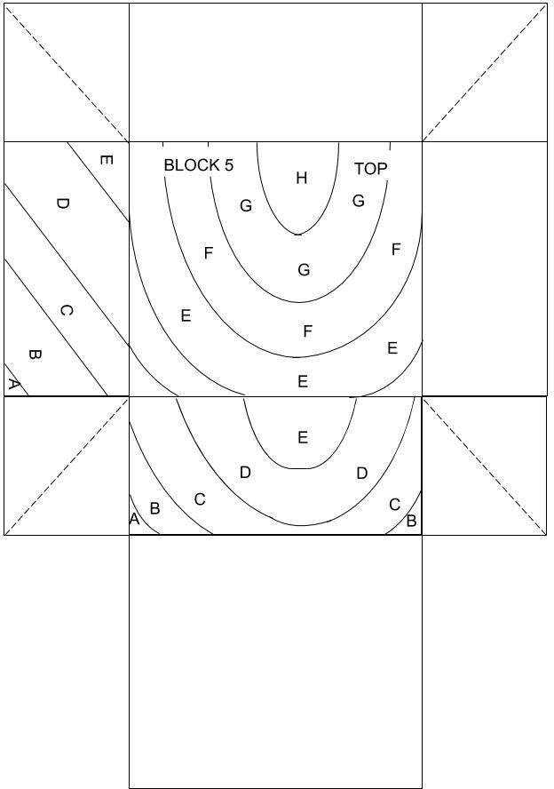
BLOCK 5
Complete the remaining sides of this block diagram. (Some information has been provided for you.) Draw in all contacts and label all units.
Put accurate strike and dip symbols on each unit on the map.
What structure(s) occurs in this diagram?
Is/are the structure(s) plunging or not plunging?
Draw the appropriate symbol(s) for this/these structure(s).
Which unit is the youngest? Which is the oldest?
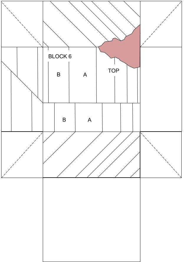
BLOCK 6
Complete the remaining sides of this block diagram. (Some information has been provided for you.) Draw in all contacts and label all units.
Put accurate strike and dip symbols on each unit on the map.
What structure(s) occurs in this diagram?
Is/are the structure(s) plunging or not plunging?
Draw the appropriate symbol(s) for this/these structure(s).
Which unit is the youngest? Which is the oldest?