10 Lab 10—Geologic maps and cross sections
In much the same way that topographic maps project the three-dimensional shape of earth’s surface onto a two-dimensional map, geologic maps project information about bedrock geology onto a two-dimensional surface. In general, geologic maps show you what bedrock would be evident at a given location on a map once the soil and vegetation are stripped away. In addition to labeling the type of rock, geologic maps will have the age of rocks, names of rock formations, and structural information such as faults, strikes and dips, and geologic cross sections.
Geologic maps are a fundamental tool for every geologist. To interpret a geologic map, you must have a working knowledge of map reading, principles of stratigraphy, the geologic time scale, rock types, and structural geology. Essentially, the lab you are doing today is a synthesis of all we have covered thus far in this semester. Once one can read a geologic map, they can be given a map of a location they have never visited, or even heard of, and tell a reasonable story about the geologic history of that place.
For today’s lab you will use geologic and elevation maps of Kentucky to answer a set of questions guiding you through the interpretation of Kentucky’s geologic history. You will find 8 ½” by 11” copies of these maps in your lab manual as well as a few larger, more detailed geologic maps of Kentucky in the classroom that need to be shared.
Follow the same lab report structure used for all other labs in this course. For the discussion section of your lab report this week, please summarize in paragraph form or using a bullet-point list, whichever is more comfortable for you, the geologic history and setting of Kentucky.
PART 1: Broader context
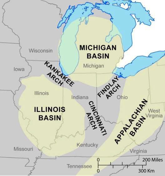
Figure 10.1. Regional tectonic map of the midwestern United States (2019)
- How many tectonic regions does Kentucky span? What are their names?
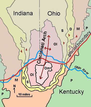
Figure 10.2. Generalized geologic map of Cincinnati Arch (Stoffer, 2015)
2. Compare the age of the rocks in the center of the Cincinnati Arch with the ages of the rocks further away. Considering this and the structure symbols in figure 10.2, what structural feature is the Cincinnati Arch?
PART 2: For questions 3–15, refer to the geologic and topographic maps of Kentucky (Fig. 10.3 and Fig. 10.4, respectively).
- How does the map pattern indicate that the rock layers underlying Kentucky are flat lying to gently dipping?
- What age of rocks are found around Highland Heights, in fact, all along the Ohio River in northern Kentucky and southwestern Ohio?
- What fossils are commonly found in this unit?
- Where is the highest topographic point in Kentucky? Explain its occurrence using bedrock geology.
- What are the oldest rocks beneath the state of Kentucky?
- What age are they?
- Where do they crop out at the surface?
- As you drive from Highland Heights, KY, to Cairo, IL, the rocks get progressively [older or younger—pick one] in age.
- How can you explain this age progression?
- Considering what you have learned so far, what geologic structure(s) do you see expressed in the Bedrock Geologic Map of Kentucky? Draw the corresponding map symbol(s) on your 8 ½” x 11” copy of this map.
- What patterns do you see that lead you to that conclusion?
- Draw strike and dip symbols on your 8 ½” x 11” map.
- Using Steno’s principles of stratigraphy, draw an estimated geologic cross-section for the 8 ½” x 11” Bedrock Geologic Map of Kentucky:
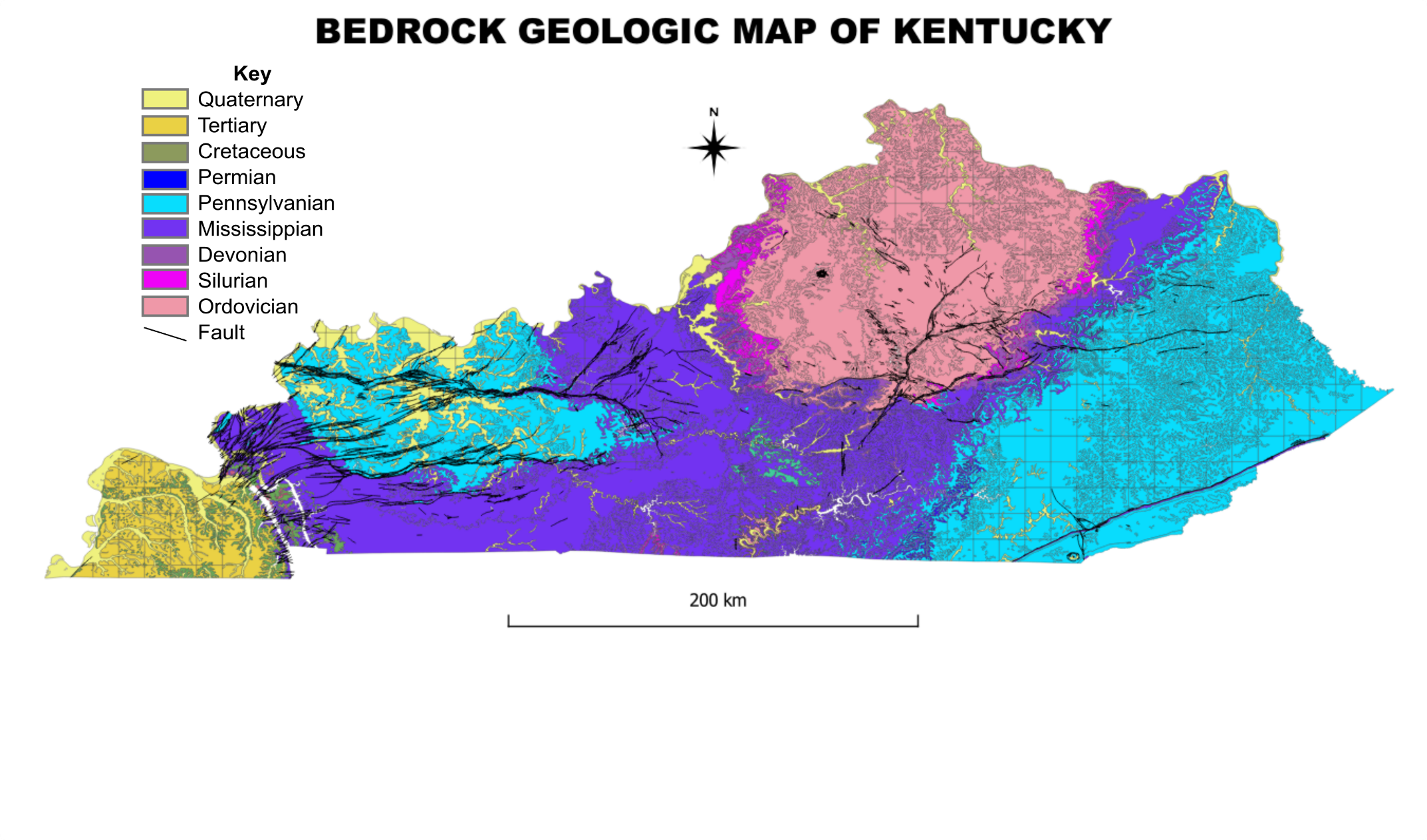

Figure 10.4. Topographic Map of Kentucky. For the full, interactive version, go to https://en-us.topographic-map.com/maps/ag/Kentucky/.

CONTRIBUTIONS TO THE GEOLOGY OF KENTUCKY
The Geologic Map of Kentucky shows the distribution of sedimentary strata totaling as much as 15,000 ft in thickness and ranging in age from Middle Ordovician to Holocene, with minor amounts of Permian intrusive rocks. The seven columnar sections on the map portray the subdivision of the sedimentary sequence into stratigraphic units and graphically indicate the general lithic character of these units. In addition, eight diagrams on the map illustrate complex stratigraphic relationships. A correlation chart of the stratigraphic units used on the map has been published separately (McDowell, 1981).
This section presents descriptive summaries of the stratigraphic units in Kentucky, grouped by system; they were prepared (in most cases) by geologists who have been closely involved in analysis and mapping of the units during the cooperative mapping project. These summaries provide details of lithology, occurrence, and correlation that could not be included on the State geologic map; many of the summaries also discuss origins of the nomenclature, type localities, depositional environments, and regional aspects of the depositional basins and give references to more extensive or detailed published stratigraphic analyses.
The descriptions of the rocks in each subsection are given by map unit as used on the State geologic map. This necessitates combination or division of some formal stratigraphic units, as well as multiple descriptions of a few formations that are shown in different map units in different regions of the State.
The few map units that include systemic boundaries are described primarily under the system to which most of the unit is referred; for example, the New Albany Shale is discussed in the summary of the Devonian.
Continuing studies have resulted in some revisions of the nomenclature used on the geologic map, specifically in the Silurian and Mississippian of eastern Kentucky and the Pennsylvanian of western Kentucky. The descriptions are keyed to the stratigraphic units used on the map, but the revised nomenclature is also presented for comparison and future reference.
This page is https://pubs.usgs.gov/prof/p1151h/stratigraphy.html; last access 1 July 2021 Created 01-09-01
Maintained by Eastern Publications Group Web Team
By Earle R. Cressman and Warren L. Peterson
Approximately 1,400 ft of Ordovician rocks are exposed in Kentucky. The Ordovician is the oldest system that crops out in the State, and the base is not exposed. In most areas the Ordovician is overlain disconformably to paraconformably by the Silurian, but in the southern Bluegrass region from Lebanon in Marion County to south of Stanford in Lincoln County (sheet 2) rocks of Devonian age rest directly on the Ordovician as a result of post-Middle Silurian to pre-Middle Devonian arching and erosion along an ancestral Cincinnati arch.
By far the largest area of exposure of the Ordovician rocks is in central and north- central Kentucky along the crest and flanks of the Cincinnati arch (figs. 1, 2). The area of exposure, approximately 7,600 mi2, is coincident with the Bluegrass region (see physiographic diagram on sheet 1 of the geologic map). The Inner Bluegrass is underlain by Middle Ordovician rocks (fig. 1), and the Outer Bluegrass by Upper Ordovician rocks (fig. 2). Upper Ordovician rocks also crop out in two smaller areas in the south-central part of the State. These are along the Cumberland River and its tributaries from Wolf Creek Dam downstream to the Tennessee border and in southern Allen County along several tributaries to the Barren River.
The Middle Ordovician consists mostly of limestone. The lower part, the High Bridge Group, is mostly of sparingly fossiliferous micrite and minor dolomite that was deposited in shallow lagoons and on tidal flats; the upper part, the Lexington Limestone, is mostly very fossiliferous limestone and fossil-fragmental calcarenite. The Upper Ordovician section consists of interbedded fossiliferous limestone or dolomite and shale; shale dominates some parts of the section, and limestone or dolomite other parts. Both the Lexington Limestone and the Upper Ordovician rocks were deposited in tropical latitudes in shallow marine water on a shelf that sloped gently northward.
This page is https://pubs.usgs.gov/prof/p1151h/ordo.html; last access 1 July 2021 Created 01-09-01
Maintained by Eastern Publications Group Web Team
By Warren L. Peterson
The Silurian rocks crop out in Kentucky in narrow arcuate belts on the east and west flanks of the Cincinnati arch and in small isolated areas mostly in south-central Kentucky (fig. 3). The Silurian rocks are of marine origin and are composed of dolomite and shale and minor amounts of limestone and chert, with a total thickness ranging from 0 to 300 ft. The basal contact is a minor erosional unconformity in much of the outcrop area; elsewhere it is probably conformable or paraconformable. The upper contact is a regional erosional unconformity, and on the crest of the Cincinnati arch the entire Silurian section has been removed. The large variation in thickness is caused by erosion along this unconformity. The original thickness of the Silurian strata is not known, as the upper part has been everywhere removed.
This page is https://pubs.usgs.gov/prof/p1151h/silurian.html; last access 1 July 2021 Created 01-09-01
Maintained by Eastern Publications Group Web Team
By Roy C. Kepferle
Exposed Devonian rocks in Kentucky (fig. 5) range in thickness from 4 ft in south- central Kentucky (Cattermole, 1963), where they are cut out by a limestone-filled channel in the Mississippian Fort Payne Formation, to more than 1,000 ft along the west flank of Pine Mountain in eastern Kentucky (Alvord, 1971; Wolcott, 1974). In general, the sequence thickens away from the crest of the Cincinnati arch. Westward, in the Illinois basin, the subsurface Devonian section thickens to 1,800 ft; the upper 470 ft is shale, and the remainder is limestone and dolomite (data extrapolated from Collinson and Atherton, 1975, p. 105; Schwalb and Norris, 1980a, b, c). Eastward, in the Kentucky part of the Appalachian basin, the subsurface thickness approaches 2,000 ft (de Witt and others, 1975, sheet 1), of which more than 1,800 ft in the upper part of the sequence is shale (Fulton, 1979; Dillman and Ettensohn, 1980). Carbonate rocks of Middle Devonian age make up the basal part of the Devonian sequence in Kentucky outcrops. These include the Jeffersonville Limestone, the Sellersburg Limestone (the North Vernon Limestone of the Indiana Geological Survey), and the Boyle Limestone or Dolomite. Organic-rich black to brownish-black shale and lesser amounts of grayish-green shale are everywhere present in the Upper Devonian sequence in Kentucky. A thin bed or lamina of impure, phosphatic quartzose sandstone is common on the widespread basal unconformity; other sandstone beds, or “bone beds,” lie locally within or at the top of the carbonate rocks, as well as within the basal few feet of the overlying shale. These bone beds are attributed by Conkin and Conkin (1969) to widespread erosional unconformities preceding and during Devonian deposition.
The basal unconformity truncates rocks ranging in age from Late Ordovician on the crest of the Cincinnati arch to Middle and Late Silurian on the flanks of the arch. In most exposures, this unconformity appears planar, as in the vicinity of Jefferson County, where it can be followed without interruption for nearly a mile along the north side of Interstate Highways I-71 and I-264. Where the unconformity truncates rocks of contrasting hardness, as in south-central Kentucky (Simmons, 1967; Kepferle, 1973), the Devonian carbonates and shales are thick over easily eroded Silurian shale but thin over nearby Silurian-dolomite capped cuestas or monadnocks. The limestone and dolomite at the base of the Devonian sequence are also thicker in structurally negative areas such as the Illinois basin and the southern part of the Appalachian basin, and several areas along the Cincinnati arch where syndepositional tectonism appears to have exerted minor influence. The erosion that preceded the Middle Devonian accumulation of carbonate rocks took place during an interval of mild tectonic warping along structures such as the incipient Cincinnati arch and the tighter folds that parallel or are normal to the present strike of the Appalachian Valley and Ridge province and the Pine Mountain thrust fault.
The Devonian rocks of Kentucky accumulated in a gradually deepening epeiric sea (Kepferle, 1977, p. 41; Jordan, 1980; Ettensohn and Barron, 1981, p. 59, 69). This is inferred from the upward facies change from carbonate at the base to clay-rich shale at the top and from the lack of evidence of subaerial exposure within the sequence.
For purposes of discussion, the Devonian rocks are grouped in five general areas of outcrop (see fig. 5): (1) the west flank of the Cincinnati arch, where the rocks dip gently westward into the Illinois basin along a line extending southward from the Ohio River in Jefferson and Oldham Counties to the sharp eastward bend in the outcrop in Nelson and Larue Counties; (2) the faulted and warped Cumberland Saddle area of outcrop extending eastward and northeastward through Madison and Estill Counties and southward in discontinuous exposures to the Tennessee border; (3) the northward-extending outcrop on the east flank of the Cincinnati arch where the bedrock dips gently eastward into the Appalachian basin; (4) the discontinuous exposures in the sole of the Pine Mountain thrust fault on the west flank of Pine Mountain; and (5) minor exposures beneath the more recent sediments in the faulted Mississippian Embayment area of the Jackson Purchase region of Marshall and Lyon Counties. The carbonates are thickest in the northern part of area 1 and in area 2. The shale is thickest in the northern parts of areas 3 and 4. Thickness, composition, and paleocurrent data suggest that the source of terrigenous elastics lay to the east during much of the Devonian period (Kepferle, Lundegard, and others, 1978; Potter and others, 1979).
This page is https://pubs.usgs.gov/prof/p1151h/devonian.html; last access 1 July 2021 Created 01-09-01
Maintained by Eastern Publications Group Web Team
By George J. Grabowski, Jr.
The Mississippian System in Kentucky is represented by mostly marine sedimentary rocks which originally extended across the entire State. These rocks record a widespread shallowing of the seas during Mississippian time, with basinal and prodeltaic shales and siltstones succeeded by shelf limestones and dolomites and coastal sandstones and shales. The Mississippian rocks are widely distributed, cropping out mainly in central and western Kentucky and underlying the Illinois and Appalachian basins (fig. 6). They are economically important in some areas and locally present environmental hazards. Additional information on the geology of the Mississippian System in Kentucky is given in three recent summary papers: Pryor and Sable (1974), Sable (1979), and Rice, Sable, and others (1979). Nomenclature of the upper part of the Mississippian section along the Pottsville Escarpment of eastern Kentucky, including essentially post-Borden strata, has recently been revised by Ettensohn and others (1984). The description of map units below is arranged generally as follows: Lower Mississippian, Upper Mississippian of western Kentucky, Upper Mississippian of eastern Kentucky, and Mississippian of Pine Mountain.
This page is https://pubs.usgs.gov/prof/p1151h/miss.html; last access 1 July 2021 Created 01-09-01
Maintained by Eastern Publications Group Web Team
By Charles L. Rice
Pennsylvanian strata crop out in two broad areas of Kentucky which together represent more than one third of the area of the State (fig. 8). These deposits are in parts of two major sedimentary basins: the Appalachian basin, which contains the eastern Kentucky coal field underlying the Cumberland Plateau, and the Eastern Interior (Illinois) basin, which contains the western Kentucky coal field (see physiographic diagram on sheet 1 of the geologic map). Most workers, including some of the earliest to investigate the system such as Shaler (1887) and Burroughs (1923), believe that Pennsylvanian strata once formed a continuous deposit across central Kentucky and the Cincinnati arch. Erosion since the close of the Paleozoic has removed many hundreds, perhaps thousands, of feet of Pennsylvanian and older strata from the structurally higher areas such as the Cincinnati arch, which separates the two basins, and has resulted in the present outcrop pattern. The distance between the two basins is much less than is apparent at first glance: close inspection of the geologic map shows that the easternmost salient of the western Kentucky coal field, on hilltops on the county line between Taylor and Larue Counties (Moore, 1976), is only about 45 mi from outliers of the eastern Kentucky coal field, on hilltops along the county line between Casey and Pulaski Counties (Lewis and Taylor, 1974).
The Pennsylvanian rocks of the two basins are lithologically similar and consist largely of sandstone, siltstone, and shale. Coal beds and thin marine shale and limestone units are widespread and occur in most parts of the stratigraphic section. These deposits indicate that in Pennsylvanian time Kentucky was near sea level, alternately covered by lakes, extensive swamps, shallow bays, and estuaries. Thus piedmont, alluvial, and coastal-plain environments extended across the State at times during the Pennsylvanian, resulting in the deposition of the strata of the two great coal fields.
The western Kentucky coal field contains, at the top of the section, a few hundred feet or more of strata of Permian age (Kehn and others, 1982). These beds are described in the section on the Permian System.
This page is https://pubs.usgs.gov/prof/p1151h/penn.html; last access 1 July 2021 Created 01-09-01
Maintained by Eastern Publications Group Web Team
By Robert C. McDowell
Permian rocks occur in Kentucky as minor igneous intrusives and as a few hundred feet of sediments at the top of the Paleozoic section in the western coal basin. These sediments, shown on the columnar section for western Kentucky, sheet 1 of the geologic map, as the uppermost part of the Sturgis Formation (PPS), have subsequently been removed from the Sturgis and renamed the Mauzy Formation (Kehn and others, 1982).
The igneous intrusives are of two types: lamprophyre and peridotite dikes and sills in Caldwell, Crittenden, and Livingston Counties of the western Kentucky fluorspar district and three small peridotite intrusions in Elliott County, northeastern Kentucky (fig. 11). Both types are considered Early Permian in age on the basis of K-Ar and Rb-Sr dating of biotite (Zartman and others, 1967). They constitute the only outcropping igneous rocks in Kentucky.
This page is https://pubs.usgs.gov/prof/p1151h/permian.html; last access 1 July 2021 Created 01-09-01
Maintained by Eastern Publications Group Web Team
CRETACEOUS AND TERTIARY SYSTEMS
By Wilds W. Olive and Robert C. McDowell
Cretaceous and Tertiary strata in Kentucky are restricted mostly to the Jackson Purchase region of far western Kentucky (see fig. 18 or physiographic diagram on the geologic map). Pliocene and possibly upper Miocene sediments are also found with Pleistocene sediments in continental deposits that occur in the Jackson Purchase and elsewhere in western Kentucky; these younger units are discussed in the section on the Quaternary System. This section concerns the post-Paleozoic strata (see columnar section for western Kentucky on sheet I of the geologic map) that are distributed throughout the Jackson Purchase beneath a veneer of Miocene(?) to Holocene continental deposits, loess, and alluvium (fig. 12).
This page is https://pubs.usgs.gov/prof/p1151h/cret.html; last access 1 July 2021 Created 01-09-01
Maintained by Eastern Publications Group Web Team
By Robert C. McDowell and Wayne L. Newell
Quaternary deposits occur locally (along with minor amounts of Miocene(?) or Pliocene sediments) as a relatively thin surficial veneer in all parts of Kentucky and as thick and extensive sequences in northern and western Kentucky. The mappable deposits are of three main types: high-level fluvial deposits, underlying Pliocene and Pleistocene terraces; glacial deposits and loess, of Pleistocene age; and alluvium, underlying Pleistocene and Holocene terraces and flood plains. The Quaternary sediments consist of unconsolidated gravel, sand, silt, and clay and locally contain sparse to abundant organic matter, including redeposited coal. During the cooperative mapping program, geology of the Paleozoic bedrock was emphasized; as a result portrayal of surficial deposits varied with the locality and the mapper. Consequently, compilation of Quaternary deposits for the Geologic Map of Kentucky required considerable generalization. Five map units are shown: continental deposits, continental deposits with loess, high-level fluvial deposits (shown as an overprint), glacial deposits, and alluvium. Continental deposits (with or without loess) have been mapped only in far western Kentucky and are shown only on sheet 1 of the geologic map; high-level fluvial deposits are shown on sheets I and 2, and glacial deposits and alluvium are shown on all three sheets.
This page is https://pubs.usgs.gov/prof/p1151h/quat.html; last access 1 July 2021 Created 01-09-01
Maintained by Eastern Publications Group Web Team
